Met Office weatherman in Camp Bastion

Met Office meteorologist Simon King has just returned from Afghanistan where he has been part of a crack team forecasting the weather for our Armed Forces. He has been working with the Met Office’s Mobile Met Unit (MMU) which gives advice on the potential impact of weather on armed operations.

Simon King, MMU, Camp Bastion

Simon King, MMU, Camp Bastion

Simon has been a Met Office meteorologist for eight years and is also an Officer in the Royal Air Force Reserve having completed tours in Iraq and Afghanistan. In a war zone weather can have a major influence on military operations and during his most recent tour in Afghanistan, Simon says his forecasts helped “forewarn of a major thunderstorm which turned the ‘normal’ dirt and sand into very unpleasant muddy conditions and enabled the military to take appropriate action mitigating any major impacts to their operations.”
The MMU is a sponsored RAF reserve unit made up of around 50 Met Office volunteers who have undergone military as well as meteorological training. They help the UK’s Armed Forces and allies understand the impact of weather on military activities and can help keep troops safe.

Simon explains: “Work at the Met Office in Camp Bastion is intense, with four members of staff providing 24/7 cover doing both observations and forecasts. While the weather and forecasting is a challenge, we are also working in a hostile environment with numerous threats.”

On his most recent tour temperatures were much cooler than the average and perhaps not quite as warm as people might think for a desert. While Simon was there temperatures were around 5/6 °C or lower at night with maximum temperatures around 16-20 °C, occasionally reaching 25 °C.

In addition to his work for the military Simon King also presented the weather on 5Live Breakfast one morning live from Afghanistan. He says “as I had access to the same meteorological information in Camp Bastion as I would at my desk in the UK, it wasn’t an issue to put together a UK forecast. In fact, as Afghanistan is four and a half hours ahead of the UK, it did mean there was no 4.15am alarm call and the first broadcast was at 11am!”

As well as working in Afghanistan MMU advisors work closely with our armed forces involved in other operations and exercises in the UK and overseas. A reliable and efficient delivery system, managed by a team of dedicated MMU Engineers, ensures our advisors have access to the most up-to-date weather information, when ever and where ever they need it. This includes outputs from our high-resolution forecasting models and support from many other Met Office teams such as IT, Science, Observations, and Operations.

Posted in Met Office News | Tagged , , , , , | Comments Off on Met Office weatherman in Camp Bastion

Guest blog: RNLI lifeguards warn of beach dangers after winter storms

Brett Shepherd, Lifeguard Manager, provides some timely advice for those planning a trip to the beach as the Easter weekend approaches.

As many of our RNLI lifeguards head back to British beaches this weekend, I’m hoping for some lovely weather to herald the start of the season. But the affect winter storms have had around the coast mean that many of the country’s most popular beaches are looking very different to this time last year.

Unprecedented storms over the winter have changed the make-up of some beaches, with sand dunes in some areas being washed away leaving sheer sand cliffs. On other beaches, access points to and from the beach have changed and shifting sand has left deep channels that in turn create strong rip currents.

Our RNLI lifeguards, who have been patrolling the country’s beaches since 2001, will be keeping visitors safe on 33 beaches across the UK over the Easter bank holiday weekend. Whilst we’re hoping lots of people head out to enjoy our glorious coast, there are a couple of easy safety steps we’re urging people to take following the winter storms.

Firstly, always head to lifeguarded beaches; they are far safer environments and will help offer you peace of mind. You can download a special ‘Beach Finder’ app from our website which will tell you where the nearest lifeguarded beaches are, or check with local authorities. We’d also urge people planning on visiting a beach to check local information in advance, as the beach environment may have changed dramatically since your last visit.

Swimmers should ensure that they swim between the red and yellow flags, which mark out the safest area to swim and are patrolled by lifeguards. Lifeguards are always on hand to offer beach safety information and advice, and please take heed of local safety signage.

By highlighting the dangers before visitors arrive at the beach, we hope that we can avoid potential incidents and everyone can enjoy their time on the beach in safety.

RNLI lifeguard rescue. Copyright Nigel Millar

RNLI lifeguard rescue. Copyright Nigel Millar

Posted in Met Office News | Tagged , , , , , , | 1 Comment

Increased UV Levels

You may have noticed that our forecast for UV are indicating low to moderate levels, however there is a possibility that the levels may in fact be much higher than this today. This is due to an ozone anomaly affecting the UK at the moment where levels are noticeably lower than normal. This is quite normal and similar events have occurred previously around this time of the year. We are confident that the levels should be no higher than those of a sunny day in June.

The main factors affecting the strength of UV radiation reaching the Earth’s surface are:

  • the elevation angle (height) of the sun in the sky
  • the amount of cloud, dust and pollution in the atmosphere
  • the amount of ozone gas in the stratosphere

The presence of ozone in the stratosphere is important because it absorbs much of the UV radiation before it reaches ground level. Our UV model currently accounts for sun angle and forecast cloud amounts, but uses a “climatological” value (i.e. the average concentration for this time of year over the UK) to estimate the total ozone concentration.

During the dark polar winter, the concentration of ozone in the upper atmosphere over the pole typically decreases because sunlight is a critical ingredient in making ozone in the first place.  At the same time the circulation of air around the North Pole keeps all this low ozone air at higher latitudes near the pole.   In March and April, as the sun moves north, this polar circulation begins to break down and occasionally allows pockets of low ozone air to break away. These can sometimes pass over the UK. In these situations there will be less ozone in the high atmosphere available to absorb the UV compared to the average amount used in our forecasts. This means that the UV index could be higher than currently indicated in our forecasts particularly if forecast cloud amounts are low.  We do round-up our UV values but due to this low ozone event, the UV forecast can still be lower than the actual levels.  We are currently exploring ways to incorporate low ozone events such as this into our models to improve our UV forecasts.

It is important that, if you are in an area that is particularly sunny over the next few days, you take steps to ensure that you and your family are protected from these increased UV levels.

During the next few weeks, we will continue to keep an eye on these low ozone events (which can be seen in satellite data) in order to warn the public when they are happening.

Posted in Met Office News | 2 Comments

Cyclone Ita making landfall over Queensland

A cyclone is making landfall over Queensland, Australia with winds of up to 145 mph expected, together with heavy rain and a storm surge which is likely to cause disruption for coastal communities.

Forecasts have been successfully predicting the track of Cyclone Ita for several days which has allowed time for preparations – including evacuations from the areas directly in its path. Landfall is expected near Cape Flattery, about 130 miles north of Cairns.

Blog_1

Image of Cyclone Ita (credit: Naval Research Laboratory)

Whilst Ita is making landfall over a relatively unpopulated part of Queensland and some weakening is expected, it is likely that the cyclone will turn south and move parallel to the coast before moving back over the ocean. Thus population centres further south such as Cairns, Innisfail and Townsville may see some impacts from the cyclone.

Latest forecast track of Ita from the Bureau of Meteorology

Latest forecast track of Ita from the Bureau of Meteorology

Ita is the strongest cyclone to make landfall over Queensland since Cyclone Yasi in February 2011. Yasi caused extensive flooding and wind damage in the region just south of Cairns.

Regional warnings for Cyclone Ita are produced by the Bureau of Meteorology. The Met Office routinely supplies predictions of cyclone tracks from its global forecast model to regional meteorological centres worldwide, which are used along with guidance from other models in the production of forecasts and guidance.

Met Office StormTracker provides a mapped picture of tropical cyclones around the globe with access to the history of their respective storm tracks. There are also forecast tracks from the Met Office global forecast model out to six days ahead for current tropical cyclones, as well as the latest observed cloud cover and sea surface temperature. We also provide updates on current tropical storms via @metofficestorms on Twitter.

Posted in Met Office News | Tagged , , , , , | 1 Comment

Looking at the headlines: Is summer coming early?

Media headlines are already looking ahead to the kind of weather we can expect as we head towards summer in the UK.

Some articles refer to our 3-month outlook for contingency planners to bolster the idea that we could be in for some fine sunny weather, but this is not what our outlook says. Indeed our 3 month outlook doesn’t give any guidance on sunshine hours, and neither does it forecast warm weather of the type reported.

While it does say that above average temperatures are favoured for the UK for Apr-May-Jun, this is only in regards to the UK’s mean temperature – which takes into account both day and night for the whole three months for the whole country. For reference, the top category of above average temperatures in the outlook is about 11C to 13C. So there’s nothing in there about the exact weather we’ll see for those three months.

Similarly, there were no strong rainfall signals for wet or dry in this particular outlook.

Our contingency planner outlooks are experimental and form a part of our research and development. They are complex products based on the likelihood of five different scenarios related to both temperature and rainfall. This can help contingency planners make long-term strategic decisions based on risk exposure, but operational decisions on how to respond to any disruptive weather are based on our five day forecasts and warnings.

Our detailed short range forecasts will always provide the best possible guidance to the public on any periods of cold weather, heavy rain or spells of hot weather, giving detailed local information across the UK.

So those looking for any signs of good weather ahead should keep up to date with our forecasts, which go out to 30-days ahead, for our most detailed and up-to-date view of the UK’s weather.

Posted in Met Office News | 10 Comments

Verifying our air quality forecasts

As forecast, air quality levels were poor across some parts of the UK yesterday and that continues today.

Observations available from Defra’s monitoring network show that yesterday parts of the south east saw levels of 8 and 9, in the high category for pollutants, on the air quality index.

Given the close match between our forecast and the observations that we do have available, there’s confidence that our forecast provided good advice and that we saw air quality levels in line with expectations.

Today’s forecast is again for poor air quality in south eastern parts of the country. Observations show daily air quality index values of 10 in the London area. Conditions are expected to improve as we go into this evening and later into the week.

The air quality forecasts provided by Defra are the most detailed forecasts provided for the UK to date. It means that emergency responders, government agencies and members of the public can use the forecast to make informed decisions.

Met Office air quality forecast for 2 April 2014

Met Office air quality forecast for 2 April 2014

Measured values of daily air quality index for 2 Apr 2014 from UK network

Measured values of daily air quality index for 2 Apr 2014 from UK network

Posted in Met Office News | Comments Off on Verifying our air quality forecasts

Storm in Sahara sends dust to UK

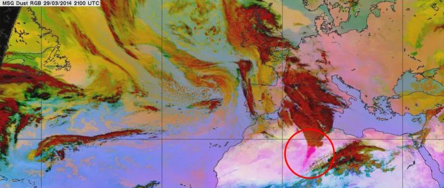
Red dust covering cars in the south this weekend was blown in from the Sahara Desert.  A large amount of sand and dust was swept up by storm winds in the desert, around 2000 miles away in northwest Africa. The airborne particles were blown north to the UK where they combined with our warm air and were deposited during showers.

Paul Hutcheon at the Met Office said “We usually see this happen several times a year when big dust storms in the Sahara coincide with southerly winds to bring that dust here. More dust rain is possible during showers expected later this week.”

Saharan dust is lifted by strong winds and can reach very high altitudes; from there it can be transported worldwide by winds, covering distances of thousands of kilometers. The dust gets caught in rain droplets in clouds, falling to the ground in rain. When the water evaporates, a thin layer of dust is left on surfaces, like cars. It can also lead to vivid sunsets.

Generally winds of more than 20 miles per hour are needed to lift sand at the Saharan Desert has been experiencing some gale force winds (over 40 miles per hour).

Saharan dust is also a contributing factor to air quality in addition to pollution levels and weather conditions.


Sahara-dust-update

The dust, shown in pink within the red circle, is carried within clouds, shown in red, to the UK, where it falls within rain showers.

Posted in Met Office News | Tagged , , , , , , , , , | 5 Comments

Celebrating World Meteorological Day

Every year on the 23rd March meteorological services around the world celebrate World Meteorological Day to mark the creation of the World Meteorological Organization (WMO) in 1950.  This year’s World Meteorological Day theme is ‘Weather and climate: engaging youth’.

World Meteorological Day 2014WMO is engaging with young people through a variety of ways, including:

  • A new and revamped “Youth corner” website providing fun information like ‘how to make a tornado in a jar’ or ‘creating a portable cloud’.

The Met Office is continually looking at ways to get young people engaged in the fascinating world of weather and climate. Here are some of the things we’re doing:

Inspiring the next generation with EDF Energy

This Met Office and EDF Energy collaboration is part of a wider partnership programme to help explain our science and extend science reach into new audiences.

In 2011, the Met Office began collaborating with EDF Energy to help educate school children about weather and climate science. It’s our aim to ensure that all children using EDF Energy’s The Pod have a good understanding of the science underpinning the other sustainability topics they study.

The Pod has a wide reach among teachers and children across the UK. There are now more than 17,000 schools registered and over 10 million children engaged with the Pod since it began in 2008.

Teachers can download hands-on activities designed by the Met Office, which help young people engage and develop their understanding of weather and climate topics. These activities include the ‘Degrees of change’ which addresses historic temperature records and natural variability and ‘Carbon Cycle Capers’, an activity that teaches children about carbon sinks and sources.

STEM Ambassadors at the Met Office

Science, technology, engineering and mathematics (STEM) is at the heart of the Met Office. Without continued expertise in these fields, we would not be able to maintain its position as the United Kingdom’s national weather service and a leading centre for climate research. We need to attract the brightest people and enable our employees to develop their professional skills during their careers.

One way to fulfil these aims, is to engage in STEM outreach and we have seen our STEM Ambassador team grow from 10 four years ago to more than 120 active ambassadors across the UK today. The STEM outreach programme is embedded into Met Office culture, bringing benefits to both the Met Office and its wider communities.

The work of our STEM Ambassadors varies hugely – from visits to local schools to talk about science or careers to running climate science workshops to weather balloon launches and code clubs. Ambassadors also take part in national events such as The Big Bang and work with other organisations engaged in STEM outreach.

Met Office Science Camp

In the summer of 2013, the Met Office ran a series of pilot events, providing an educational science night for young people aged 11–12 at the Met Office headquarters in Exeter.

These Met Office Science Camps have proved to be a great success. Over four events, 176 children from local schools and scout/guide groups got hands-on with STEM at the Met Office. They camped overnight in onsite conference rooms, helped along by a team of over 100 staff volunteers who represented almost every area of the Met Office’s work.

The feedback from the students was overwhelmingly positive; saying they would recommend Met Office Science Camps to a friend. The feedback from staff was equally positive, saying that they would recommend volunteering to colleagues and would take part and help organise future events again.

Building on the success of Met Office Science Camp 2013 we will run four events over the summer of 2014, endeavouring to make each one bigger, louder and more fun.

Interested in a career in science?

To mark World Meteorological Day, The Royal Meteorological Society is working with the Met Office, the University of Reading, the Institute of Physics and local schools, to run a Twitter session on careers in science.

They will be answering questions on the physics of the environment and meteorology. There are some great interviewees taking part including Prof Iain Stewart, scientist and broadcaster; Prof Marshall Shepherd Director, Atmospheric Sciences Program, University of Georgia and ex President of the American Meteorological Society and academics from various universities. From industry we have experts; including Dominic Sindall, Head Catastrophe Risk Analyst at Faber Global Ltd and others. The Abbey School, Reading will also be taking part.

You can join the Twitter conversation between 2pm and 4pm on Thursday 20 March. To join in, follow @rmets and use #sciencecareers. More information on how to take part can be found here.

Posted in Met Office News | Tagged , , , , , , , , | 5 Comments

Spring has sprung

Warmer, drier weather is on the way for parts of the country.  As we move through the week a north–south divide develops across the UK with Scotland, Northern Ireland, northern England and parts of Wales being changeable and windy. However in the south high pressure will dominate  bringing dry weather for the weekend, with the best of the weather in the Southeast.

Temperatures are expected to reach mid to high teens in the South this weekend (8th – 9th March), while northwest England and Scotland are likely to see spells of strong winds and rain and there is a risk of overnight frosts.

This is in sharp contrast to the record breaking winter we have just experienced.  It was the wettest winter for the UK, England, Wales and Scotland, and the second wettest winter for Northern Ireland in the record series dating from 1910. It was the stormiest UK weather for 20 years with at least 12 major winter storms affecting the UK in two spells from mid-December to early January, and again from late January to mid-February.

For a time early next week the temperatures are expected to return to nearer normal, or slightly above, the average for the time of year (9 °C).  High pressure is again expected to dominate through next week leaving largely settled conditions it should continue to feel “spring like” with some sunshine around and light winds.

When does Spring start?

Meteorologically speaking spring stretches from 1 March to the end of May. Astronomically, spring typically starts on the day of spring equinox, around the 20 March in the Northern Hemisphere.

Weather in spring is often calm and dry with temperatures rising in the day but staying cool at night.

Posted in Met Office News | Tagged , , , , , , , , | 2 Comments

The Met Office’s outlook for UK winter 2013-14

There are some headlines in the media today discussing the Met Office long range forecast for this winter.

Firstly it’s important to remember that it’s our short and medium term forecasts that are relied on by emergency responders to help them manage the impacts of severe weather.

The Met Office’s five-day forecasts and severe weather warnings have provided excellent guidance throughout the period of exceptionally stormy and wet weather we have experienced this winter. This advice has helped everyone from the emergency services, to government organisations and the public plan ahead for the conditions we’ve seen.

The news stories are based on information taken from our three month outlook for contingency planners, issued at the end of November 2013 so, what can our three month outlooks tell us?

These outlooks are not like our other forecasts because, as we have discussed previously, it’s not currently scientifically possible to provide a detailed forecast over these long timescales.

Instead, the outlook assesses the level of risk connected to five different scenarios for both temperature and rain/snowfall for the UK as a whole; they do not mention specific areas such as the West Country or the Somerset Levels. It’s a bit like the science-equivalent of factoring the odds on a horse race.

However, as with any horse race, it’s always possible that the favourite won’t win – so these probability scenarios have to be used in the right context. This is why they’re useful for contingency planners who plan ahead based on risk, but not that useful for the general public.

Posted in Met Office in the Media, Met Office News | Tagged , , , , , , , , , , | 36 Comments