
January 2024 brought a month of contrasts to the UK weather, with three named storms, a significant spell of cold, wintry weather and finally a new UK daily maximum temperature record for January.
Temperatures and rainfall amounts have varied throughout the month, with mild and wet weather interrupted by a cold and dry spell from the second week of January, albeit with some significant snow for northern areas of the UK.
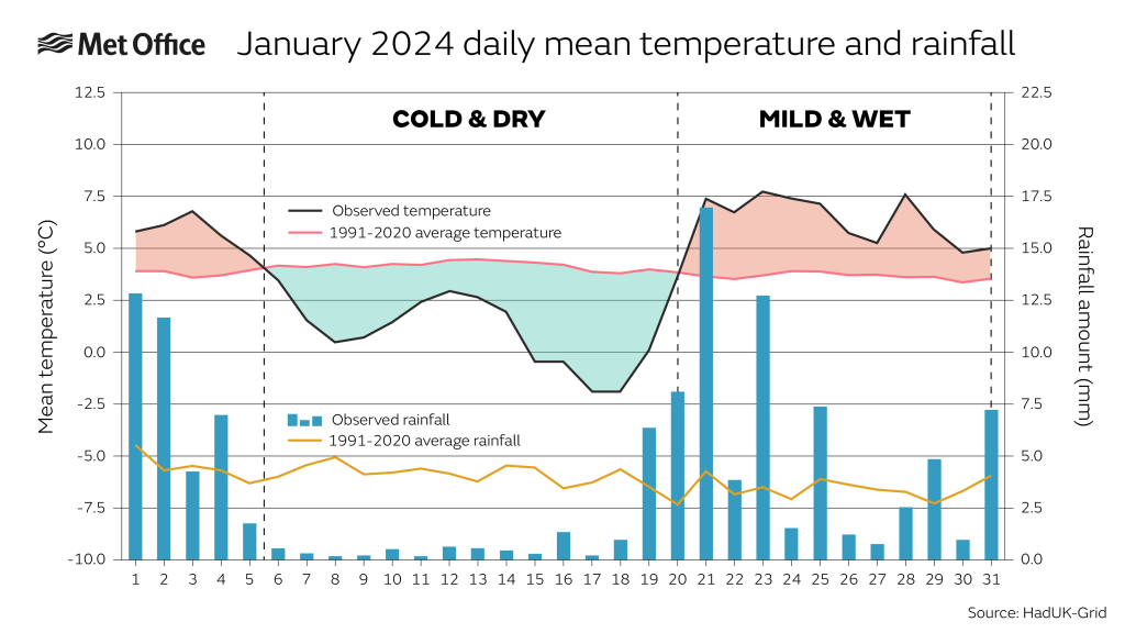
Overall, this means that the average mean temperature for the UK for January 2024 is near average according to provisional Met Office figures. UK mean temperatures ended the month at 3.8°C, around 0.1°C lower than the long-term average for the month.

The fluctuations in rainfall throughout the month also resulted in near-average rainfall amounts for the month, though Northern Ireland and Scotland were drier than average. UK rainfall was 3% less than average, with 117.5mm of rain. Northern England saw 22% more rain than average, with 111.9mm falling in the month.

Met Office Senior Scientist Mike Kendon said: “Overall, the UK temperature and rainfall for January were fairly near average but these belie the fact that the weather has never been too far away from the headlines. Storms Henk, Jocelyn and Isha all brought significant impacts, as did the cold and snowy conditions around the middle of the month.
“Of course, contrasting winter weather in the UK isn’t a new phenomenon, as subtle shifts in the jet stream can lead to significantly different conditions in the UK. This month we’ve seen clearly how cold northerly winds can bring winter hazards, while Atlantic westerlies can bring some impactful storms. When you add in a late-month warm spell from the south, you get a sense of the mixed conditions the country has had. What this January clearly demonstrates is just how abrupt these changes in weather type can be.”
Gardeners will be glad of more subdued rainfall figures compared to the wet conditions of December, according to Royal Horticultural Society Chief Horticulturist Guy Barter. He said: “Gardeners will have been grateful for a break in January from the rainy autumn and winter weather that has hindered getting the garden ready for spring.
“Although conditions have been pleasant, a cold, but not bitter, January is favoured by gardeners as it holds back the spring flowering of fruit trees and bushes that are vulnerable to frost damage if they flower too early. Gardeners will be hoping for a dry, chilly February.”
Contrasting temperatures
A northerly flow of air resulted in a period of significant cold weather from around the second week of January, with snow and ice hazards for many in the northern half of the UK, especially the north of Scotland. Shetland was particularly hard-hit with bitter northerly winds and temperatures struggling to rise much above freezing with deep lying snow.
On 17 January, -14°C at Dalwhinnie (Invernesshire) was the lowest temperatures dipped in the month, with a snow depth of 37cm reported at Altnaharra (Sutherland) on 18 January. Despite the UK’s warming climate, spells of wintry weather are to be expected and this was one of the more notable such spells since the exceptional December of 2010.
On the flip side, the month started mild and very wet and has concluded mild, with a new UK daily maximum temperature record for January of 19.9°C recorded at Achfary on 28 January. This is also Scotland’s highest winter temperature on record.
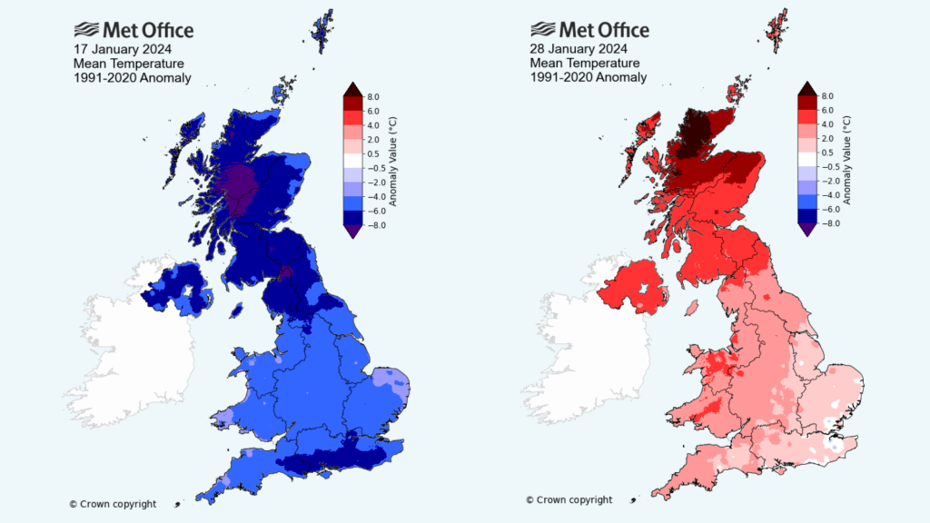
Mike Kendon explained some of the meteorological factors behind north-west Scotland’s unusually high temperatures near the end of the month. He said: “The Foehn effect causes a marked contrast in temperature across a mountainous area, with cooler, moister conditions on the windward side and warmer, drier conditions on the leeward side as the air dries out as it is forced up and over the higher ground.
“This effect can be responsible for some unusually high winter temperatures in both Scotland and Northern Ireland, although these tend to be highly localized. While the Foehn effect was the primary cause of this record, we must set this against a backdrop of increasing mean and maximum temperatures more generally as our climate continues to warm.”
Since 2011, the UK has recorded a new individual highest maximum daily temperature extreme for six of the 12 months of the year – January (2024), February (2019), July (2022), October (2011), November (2015) and December (2019). In contrast, none of the UK’s individual lowest minimum temperature extremes in a month have occurred this century.
The below maps show contrasting temperature anomalies seen in the month, with a cold pool of air on 17 January and a warm southerly flow coupled with the Foehn effect in parts of Scotland on 28 January.
A sunny start to the year
Despite the mix in conditions, sunshine was a relatively frequent visitor in January.
The UK had its sixth sunniest January on record in a series which goes back to 1910. There were 61 hours of sunshine on average in the UK, which is 28% more than average. The relatively sunny month was a welcome contrast to December, with just 27.9 hours, around two-thirds of normal and less than an hour a day.
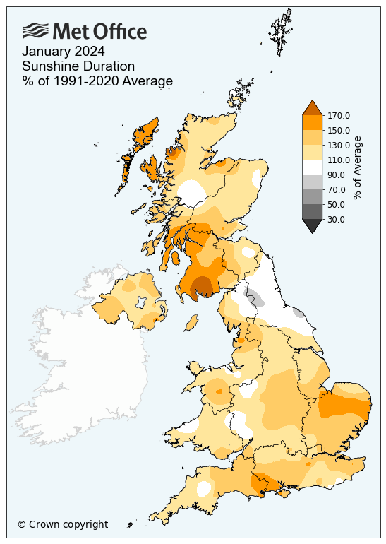
January’s sunny theme was replicated across much of the UK, with England and Scotland recording sunshine amounts within their top ten sunniest for the month, with Wales and Northern Ireland also seeing sunshine amounts well above average.
Three storms in the month
Three named storms impacted the UK in the month as Henk, Isha and Jocelyn brought strong winds and heavy rain for some. A recent blog looks at the underlying factors behind what has been a stormy autumn and winter so far.
Henk brought significant flooding impacts as well as strong winds, while Isha was the most notable windstorm since Eunice in 2022, with extensive Amber wind warnings issued by the Met Office as well as an unusual overnight red warning for some. A gust of 99mph was recorded in Northumberland as part of Storm Isha.
Storm Jocelyn, which was named by Met Eireann, continued to bring strong winds to much of the north of the UK.
| Provisional January 2024 | Mean temp (°C) | Sunshine (hours) | Rainfall (mm) | |||
| Actual | Diff from avg (°C) | Actual | % of avg | Actual | % of avg | |
| UK | 3.8 | -0.1 | 61.0 | 128 | 117.5 | 97 |
| England | 4.4 | 0.0 | 70.6 | 128 | 85.1 | 102 |
| Wales | 4.4 | -0.0 | 56.6 | 120 | 161.9 | 104 |
| Scotland | 2.5 | -0.5 | 46.8 | 133 | 165.1 | 93 |
| N Ireland | 4.2 | -0.3 | 55.6 | 130 | 86.0 | 75 |
Winter so far
Meteorological winter so far is tracking wetter and slightly warmer than average, though with a month still to go there is time for these figures to change significantly.
At this point in the season you’d expect to have seen 68% of the season’s total seasonal average rainfall. At the conclusion of January, the UK has so far seen 89% of the average rainfall for the whole of the season, although much of north-east England and eastern Scotland have already received more than the whole-season average rainfall, with a month still to go.


You must be logged in to post a comment.