
Professor Adam Scaife Met Office Head of Monthly to Decadal Prediction.
Winters in the UK usually include a wide variety of weather, and this winter looks to be no exception. Autumn 2022 has been remarkable on many fronts. A warm start to September and a notable warm spell from mid-October to mid-November, means this autumn has been one of the warmest on record, with mean temperatures significantly above the 1991-2020 averaging period. Perhaps more significantly, even if we were to see average temperatures for December, then 2022 could well be the warmest year on record for the UK.
While there are indications in the long-range forecast that we could see some mild weather this winter, we are expecting a colder start. Our medium-range models are starting to indicate that high pressure will begin to dominate our region in December, increasing the potential for cold spells, although we could still see wet and windy weather at times as well as later in the winter (check our 30-day forecast).
Exact weather conditions will be dictated by just where the high pressure settles over the Atlantic and the UK. While this type of outlook cannot identify day-to-day weather there is relatively good agreement that weather patterns in December will become more settled than we have seen in November. High pressure prevents mild, moist air from flowing to the UK from the Atlantic Ocean increasing the potential for lower temperatures, with some threat of snow and ice mainly in northern areas and a reduction in the chance of early winter storms compared to normal.
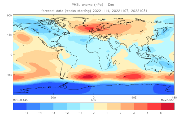
Predicted pressure anomaly (difference from normal) for December 2022 in hectoPascals (hPa)
As we head further through the winter the picture changes and current forecasts suggest that the risk of high pressure decreases in February, allowing more unsettled conditions to develop, with wet, windy, and mild spells more likely. This means that the chances of a very cold winter, comparable to 2009/10, are still low this winter. Nevertheless, although it is not predicted in the near future, there is still a risk of a Sudden Stratospheric Warming occurring later this winter. If this happens, it could increase the risk of wintry weather and could lead to a further cold spell for the UK and northern Europe.
Professor Scaife added: “Over the years the Met Office has played an important role in supporting Government and business to interpret long-range forecast probabilities to help them make risk-based decisions. The long-range outlook cannot identify the weather on a given day or even week, so it is not very useful if you want to know if we will see snow on Christmas Day. Nevertheless, certain industries and sectors of society do find this type of information helpful. Especially those who can benefit from insight about the coming season, such as whether it is more likely to be wetter or drier, warmer or colder, windier or calmer than average.
An indication of the likelihood of conditions that impact transport, energy, health etc. can allow planners in these sectors to prepare accordingly. As we go through the winter months, we will be able to give more detail of potential winter hazards and will issue updated forecasts and warnings each month and as and when needed.
Winter Weather Drivers
The science in this area is at the cutting edge of meteorology and the Met Office is one of the leading lights in scientific research in the area. However, even with ‘perfect’ prediction systems and ‘perfect’ meteorological observations, the fundamental chaotic nature of the atmosphere will still limit the skill of these predictions. Although, the science does not allow for specific detail on the amount of rain or snow over the coming months or exactly when severe weather may occur, long-range forecasts can provide useful information on the possible conditions averaged over the UK for a season as a whole.
These predictions are driven by global weather patterns and their influence on the UK increases through late autumn and into winter. The global weather patterns that may influence our weather over the next three months are:
La Nina, a cooling of the tropical Pacific Ocean, which promotes the development of high pressure in the Atlantic in early winter, increasing the chance of winds from the north or northwest early in the winter and increasing the chance of westerly winds later in the winter.
- The Madden Julian Oscillation, an eastward progression of large regions of tropical rainfall from over the Indian to the Pacific Ocean, increasing the chance of blocking patterns in early December and potential spells of colder UK weather early in winter.
- The Quasi-Biennial Oscillation (QBO), a regular variation of the winds that blow high above the equator. The QBO is currently in a westerly phase which increasing the chance of westerly winds from the Atlantic.
Even if these influences suggest an overall higher-than-usual chance of a cold start to winter, this will not rule out having wet and windy spells, or even a mild winter overall. These scenarios would just be less likely based on the information available at the time the forecast is made. It is important to keep up to date with our regular monthly updates to the long-range outlook.
You can check the long range forecast and daily weather forecast on our website. You can also follow us on Twitter and Facebook, as well as on our mobile app which is available for iPhone from the App store and for Android from the Google Play store. Our three month outlooks are updated each month. Keep track of current weather warnings on the weather warning page.

You must be logged in to post a comment.