
This week many places have seen the type of weather you may usually associate with winter than late April, with wintry showers observed as far south as southern counties of England. However, snow at this time of year is not as unusual as you might expect.
Based on records from 1981 to 2010 the UK average is for 2.3 days of snow in April, which is more than the 1.7 days for an average November. Whilst the beginning of April is more likely to be white than the end of the month, there have been a number of notable snow events this late on.
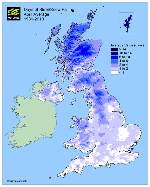
Map showing average number of days with snow/sleet falling in April
Perhaps the most outstanding April snow event occurred in 1981 when there was significant snowfall widely from the 24th to the 28th. On 25 April over 30cm of snow was recorded over the high ground of the Pennines, with 29cm in Sheffield and 26cm in Buxton. The following day 25cm of snow was recorded at Okehampton, Devon, with 20cm at Blaisdon, Gloucestershire and 14cm at Corsham, Wiltshire. The heavy snowfall with blizzard conditions led to disruption to power supplies and travel.

Snow in Crookes, a suburb of Sheffield, 27 April 1981 (courtesy David Parker, Met Office Hadley Centre)
In 1989 there were late-April snow showers across parts of southern England, and even last year there was snow at the end of April in Aberdeenshire.
We have also seen some snow events in May. In 1979, it snowed every day somewhere in the UK between 1 and 6 May, including parts of the south and southeast. On 6 May 1997 over 200 stations across the UK recorded falling snow.
Hail or snow?
Some wintry showers observed this week were of hail rather than snow. Snow forms when tiny ice crystals in clouds stick together to become snowflakes, and fall to the ground when they become heavy enough. In the UK the heaviest snow falls tend to occur when the air temperature is between zero and 2 C.
Hail forms when ice particles or frozen water droplets get caught in updraughts of air and move up and down through the cloud. As they do so they grow in size by collecting water on their surface and colliding with other ice particles. They form ice balls then fall to the ground and can be as big as 6 inches in diameter, possibly causing some damage.
Further wintry weather is forecast over the next few days and a yellow warning for snow has been issued for parts of Eastern Scotland overnight Thursday into Friday, with some disruption possible.
Keep up to date with the latest forecast information on our forecast pages, Facebook and Twitter sites and via our Weather App.

Reblogged this on WeatherAction News.
Are we ignoring the effects of climate change?